In modern technology, LiDAR (Light Detection and Ranging) has emerged as a game-changer, revolutionizing how we collect and utilize spatial data. Traditionally, methods like photogrammetry have been the go-to for various applications, but they come with challenges, especially when the sun sets. Enter LiDAR, mainly when used at night, and the advantages become crystal clear. In this blog post, we'll explore the potential and benefits of LiDAR at night and compare it with the more traditional photogrammetry method.
Challenges of photogrammetry at night
While photogrammetry has been a reliable method for data collection during daylight hours, it faces significant limitations when the sun goes down:
- Dependence on light: Photogrammetry uses visible light to capture images. In low-light conditions or complete darkness, the accuracy and quality of data collection diminish significantly.
- Limited coverage: Traditional cameras have a restricted field of view, which can result in incomplete or inaccurate data collection, especially in complex environments or large-scale projects.
- Time-consuming post-processing: After capturing images, photogrammetric data must undergo time-consuming post-processing to create 3D models, making it less than ideal for real-time decision-making.
LiDAR: A beam of hope in the dark
LiDAR, on the other hand, operates on a different principle altogether. It emits laser pulses and measures the time it takes for the light to bounce back, creating precise 3D point clouds. Here's why LiDAR shines, especially at night:
- No natural light dependency: LiDAR sensors emit their laser light, which means they can operate effectively in complete darkness, ensuring data consistency around the clock.
- Highly accurate: LiDAR provides survey-grade accuracy regardless of lighting conditions, allowing for dependable data collection in any environment, including challenging ones like dense forests or urban canyons.
- Immediate results: With advancements like Aerial Precision's systems, LiDAR data can be processed on-site, giving instant results while still in the field. Which means you can make critical decisions without delay.
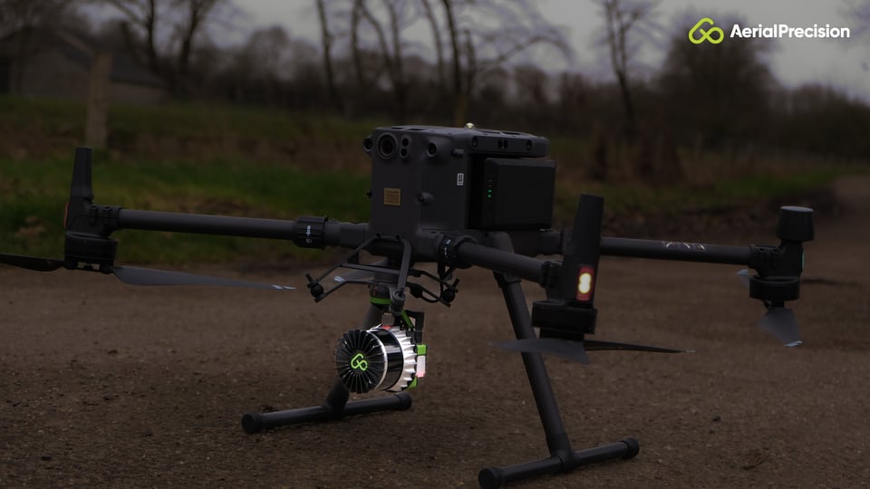
Aerial Precision's AP-LiDAR-One: The ultimate solution for all your mapping needs.
Aerial Precision is at the forefront of LiDAR technology, and our AP-LiDAR-One system is designed to provide unmatched performance and ease of use. Here's why you should consider integrating it into your nighttime operations:
- Survey-grade point clouds: AP-LiDAR-One delivers survey-grade point clouds even in challenging lighting conditions, ensuring the highest level of data accuracy.
- Real-time processing: Powered by our proprietary AP-SLAM technology, LiDAR data is processed on the iPad immediately after landing. Meaning you get instant results in the field, streamlining your decision-making process.
- Seamless integration: Our LiDAR system is designed to be ultra-light and seamlessly integrated into the most popular drones like the DJI M300 and Freefly ASTRO. This integration provides maximum potential and versatility for various applications.
In conclusion, the advantages of LiDAR at night over traditional photogrammetry are clear. Whether you're in land surveying, forestry management, infrastructure inspection, or any other field requiring accurate spatial data, LiDAR is the future. Aerial Precision's AP-LiDAR-One offers state-of-the-art technology that empowers you to unlock the full potential of LiDAR data acquisition, even in the darkest of nights.
Experience the power of LiDAR and make informed decisions with Aerial Precision. Visit our LiDAR Sensors page to learn more about AP-LiDAR-One and take your data collection capabilities to new heights.
Embrace the night and illuminate your projects with precision and confidence!