 Aerial Precision designs and manufactures intelligence-driven 3D sensing systems for commercial drones and mobile vehicles. Our focus is on delivering information that is ready to be used in decision making processes. This information is extracted in real-time from the spatial data (point clouds) captured with our sensors.
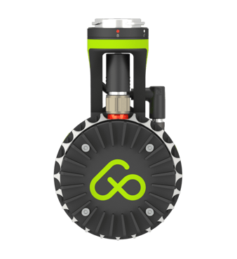
AP-LiDAR One: the lightest and most powerful LiDAR system
A few months ago we introduced AP-LiDAR-One, the first LiDAR system in our portfolio. It’s the lightest and more powerful LiDAR system on the market. Featuring the latest sensors from Ouster and our proprietary Artificial Intelligence Unit (AI Unit), this system is able to create accurate and meaningful 3D maps in real-time using LiDAR technology at a price that is competing with photogrammetry. Our AI Unit is able to understand the environment and use that information to increase the accuracy and level of detail of our 3D maps, delivering intelligence from them. AP-LiDAR-One can be mounted on small drones such as the DJI M210 or M300 RTK with the included DJI SKYPORT mount or on the Acecore ZOE or Freefly Astro with the universal mount. With the standard tripod thread provided, it can also be mounted on suction cups for mobile mapping or handheld tripods for walking scans.
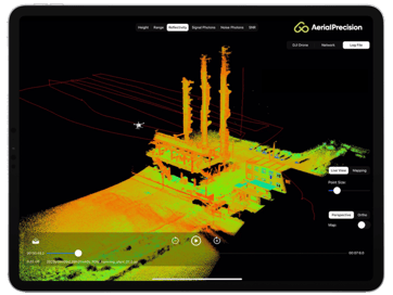 The system is managed from the iOS/macOS app provided. From it you will be able to monitor, configure and control the system and view the live point cloud being generated. Our custom designed hardware features 1024 Point Processing Cores capable of registering more than 2 million points per second. The in-house developed SLAM architecture offers unmatched real-time performance by fusing the LiDAR data with the internal precision IMU and RTK GPS sensors (or drone RTK GPS when available) with our AI algorithms further enhancing the quality of the point clouds generated.
Target industries
The potential end users of the data and information generated by AP-LiDAR-One are not limited to one category. We have defined several that includes:
- Agriculture: Supporting evidence-based planning and spatial data collection. This data can then be used for adapting farming strategies and making cultivation decisions. Drones can be integrated at every stage of the crop lifecycle, from terrain analysis and seed planting to choosing the right moment for harvesting.
- Forestry: LiDAR mapping in forestry applications is a key component for accurate forest inventory. From tree counting to individual tree height estimation and eventually biomass density calculations, our system can dramatically reduce the cost and increase the overall performance of these activities.
- Construction: The obtained 3D maps are well suited to provide the data required at each phase of the construction process. By providing better site data during the design and planning phase the speed and quality of the design process can be significantly increased. During the construction phase, aerial or handheld scans are perfect for quick surveys of sites and for the precise gathering of data for progress reports. The 3D maps created, further increase safety by monitoring construction areas for possible sources of risk and accidents.
- Telecommunications & Energy: Drones with a mapping unit can assist for infrastructure issues, specifically maintenance, planning as well as pressure to reduce costs. There are numerous advantages of using these devices to identify obstructions such as trees or vegetation proximity to power lines and assess damage after a natural disaster.
- Mining: The mining industry is one of the sectors where 3D maps usage has untapped potential to deliver significant value for businesses. Open-pit mines usually cover several square kilometres, on varying surface levels, which translates into long routes for land vehicles and crew. In open-pit mining several areas of application can be identified such as planning, extraction support, environmental protection or reporting. Stockpiles volumetric measurement can be assessed on-site with real-time reporting to the accounting team.
About Aerial Precision
Aerial Precision was founded by Vicente Payo-Ollero in Maastricht. He is an electronics engineer specialised in sensor fusion, guidance, navigation and control of unmanned systems (commonly known as drones). With plenty of experience operating high-end drones all around the world and using traditional LiDAR sensors and photogrammetry systems, he found that the way 3D maps are produced today could be improved dramatically. Michael Laddrak joined the company soon after to assist on business development and strategy. The startup graduated from the fall 2018 incubation program of Brightlands Innovation Factory, where the business model was tested and validated with customers and venture experts. With more than €500K raised as pre-seed round, 4 employees and several industry partners, the company expects that number to double by the end of the year.
The company is currently accepting orders for AP-LiDAR-One with first units shipping by the second half of the year. Contact us for more information.